 |
| From the Miami Heat Website |
You get the idea, but like the team, we will be seeing more of the heat this week. A teleconnection pattern switch will allow for a ridge to engulf the Southeast. At first I thought this was part of the Bermuda high but it is not. Before we focus on our weather, I want to show the Atlantic satellite image. The same cutoff low that I suggested last week that could support a subtropical storm seems to be well, developing into a subtropical storm.
 |
| From CIMSS. |
With a low/moderate shear environment, marginal water temperatures, the low has a short opportunity to develop into a named (likely subtropical) storm before it races towards the northeast. The storm still has a dependence on the upper level cutoff low but a surface warm core low is beginning to develop underneath it. The system is acquiring tropical characteristics but I believe it will be classified as subtropical, due to the reason stated above.
 |
| GIF image of 500mb geopotential height anomalies, from E-Wall (Penn State) |
The steady ridge that has been creating a super zonal flow across the eastern Pacific is weakening and the positive height anomaly will subside. This height anomaly along with the negative anomaly to the north will weaken the pressure gradient between the two, and thus, weaken the zonal flow entering into the Pacific Northwest. This isn't necessarily a bad thing though. The super strong zonal flow has pushed right up to the eastern edge of the northern Rockies, and has been the culprit of the lack of precipitation across the Central Rockies. This zonal flow has also kept the polar jet away from the subtropical jet stream, and with the subtropical jet the drought situation across Florida has largely been eradicated.
 |
| Zonal flow described above, from Twisterdata.com |
 |
| Instant Weather Map image of the zonal flow across the eastern Pacific. |
This zonal flow across the eastern Pacific will weaken, and instead we get a stronger zonal flow across the northern tier of the United States. With the prior setup, we have had a very strong jet push zonally across the northern Rockies and right up to the eastern crest. With the lack of wave amplitude between the eastern Pacific and the eastern Rockies, the Pacific Northwest has been getting a parade of weaker, but more frequent cyclonic storms. However, with a lack of amplitude across the Rockies, the cyclonic storms encounter the higher terrain and weaken (due to vortex squishing). With the jet exit right at the eastern crest of the mountains, cyclonic storms have been strong coming off the mountains due to vortex stretching. With the peak jet moving farther to the east, the storm track shifts farther to the north. We won't even see frontal activity cross our area until Thursday night.
 |
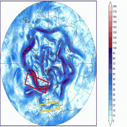
| 300mb winds, from instantweathermaps.com |
In the red box is the stronger polar jet flow into the United States and in the yellow box is a building trough associated with an upper level low from the subtropical jet. It is the subtropical jet that has been very beneficial for the Southwest U.S. and will soon provide a huge rain maker for Florida and southern Georgia at the end of this week.
But hang on, are we seeing a ridge building across central Canada in the very last image of the above animation? Yes, and this is in response to higher geopotential heights across eastern Canada and Greenland. If this is starting to become more difficult to understand, don't feel bad because I had to sit and think about this for a while myself.
 |
| Surface precipitation (Wednesday) with 1000mb - 500mb height thickness contours (from www.weather.unisys.com) |
 |
| 850mb temperature and pressure contours, from www.weather.unisys.com |
The last two images are ugly, with a strong high FIRMLY over the eastern half of the United States. There is enough of a southerly flow in place for isolated convective showers in the afternoon.
 |
| 500mb height level, Wednesday *very warm* |
 |
| 500mb height level, Friday *still warm* |
 |
| 500mb height level, next week. *Hope?* |
The 3-day and 6-day forecast is bleak, for those like me wishing for a cooler summer. But the end of the model run is encouraging, with a ridge building across both the Midwest and....wait for it....Greenland. The EURO shows this happening a little earlier but is on the same track.
 |
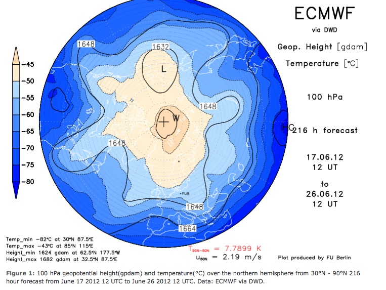
| Source: Berlin Stratosphere Group |
Verdict - this week = very warm, with highs in the lower/mid 80's. A weak front pushes the temperatures down about 3-5*F on Friday. Another teleconnection shift will favor the reduction of the ridge promoting the hotter weather by next week.


No comments:
Post a Comment