 |
| January - March 2012 Geopotential height anomalies. Red = higher heights (warm areas) blue = lower heights (colder areas). |
The strong ridge across the Pacific and the strong trough over Alaska induced a strong pressure gradient, strengthening the jet here (due to the steeper gradient change).

The mean jet stream from January 2012 to March 2012. Notice the anomalously strong jet over the Pacific Northwest, and how it penetrates across the northern states. The jet actually isn't weaker across the central United States. Rather, it is descending down to another level. Across the east coast it rises back up to that level. See how the highest values are well off the east coast and do not pass over the Southeast? Lets look at the prior winters.


The much more benign winter of 2010-2011, which had a brutal start but a slow finish. The jet stream entering the Pacific Northwest is stronger but not nearly as strong as this prior winter. Most of the strong values over the Southeast are from December 2010 alone. That's how far south the trough was during that winter.

Enough reminiscing about the past, lets get to the meat of the forecast. A split in the primary jet stream will put the High Country in between the storm tracks. A building upper level ridge this weekend will keep the area sunny to partly cloudy and displace the trough that has been keeping the High Country in unseasonably cool weather. The polar and subtropical jet stream are both defined, unlike last summer where the subtropical jet stream was heavily suppressed. The subtropical jet stream is weaker, and found at a higher height level due to the warmer (and thicker) atmosphere. The end result of a trough of the southerly jet is below.

The next 3 figures are winds at the 250mb level.
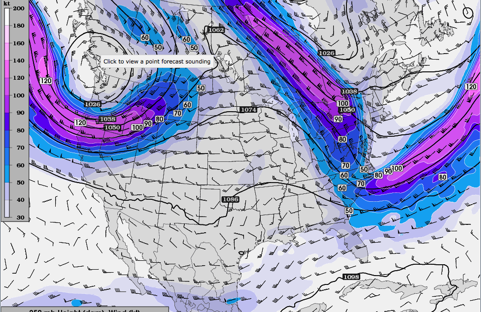 |
| Friday winds. The backside of the trough will funnel in remnant cold air in the morning but I am expecting a wind shift tomorrow. Rainfall is confined to the eastern Gulf Coast and Florida. |
 |
| Saturday winds. Notice the slight colors at the bottom of the figure. This is actually the southern branch of the jet, augmented by the lack of a strong zonal flow into the Pacific Northwest. Notice the building trough across the southern jet. At this point the rainfall will be confined to the Gulf Coast, due to the close proximity of the descending portion of the northern jet stream. |
 |
| Sunday winds. Stronger southern jet flow and building trough in the southern jet will support slight synoptic ascent across Florida, Georgia, and southeast South Carolina. Rainfall will be here. |
 |
| Positive geopotential heights over Greenland and the Arctic are inducing the expansion of cooler weather across the East Coast. Weaker polar jet is allowing for a southerly branch to have some weight in this forecast. |
 |
| We have a retreat of the higher pressure over the Arctic, and with that the cooler weather retreats as well. We start to see a building ridge across the Great Lakes Region. This is not a deep ridge nor is this ridge linked to the Bermuda high but is an upper level ridge. |
Looking ahead, I see an expansion/contraction of the Bermuda High but no sign of there being a steady state Bermuda High extending over the Southeast. Rather, a welcoming southerly jet will keep Florida and the Gulf Coast in a wetter weather pattern, and this may occasionally encompass Georgia and the Carolinas with it. The northerly branch will not envelop the High Country with NEARLY as much frequency but it's proximity, along with the southern branch, will keep the High Country in a more consistent temperature pattern than last summer.
Verdict: The next several weeks continue the wet and mild weather pattern. Hot weather will not be able to get a foothold over the Southeast and precipitation will be abundant.
Hooray for milder summer! agreed on keeping the Bermuda High as far away as possible!
ReplyDelete