|
| Height anomalies for the next 10 days. Red = warm, blue = cold. Notice the persistent warm anomaly over Southeast Canada (white box) and the resulting cooler weather (blue box). This may be a pattern setting up for the long term. 6/8 winters listed below had this pattern leading into it. |
The Pacific Decadal Oscillation failed to switch into a positive phase and is dropping back into a medium negative phase. The warm phase of ENSO has also weakened, but significant upwelling of warmer water will re-energize El Nino conditions. Originally I thought we would be sitting in a very easterly oriented El Nino, but by the time winter rolls around, El Nino will be more oriented towards the central Pacific. The neutral orientation of ENSO will partially offset the negative phase of the PDO. I have pulled several winters that exhibited a medium negative phase PDO and a weak neutral to slightly easterly oriented ENSO. The conditions I have used are unique. I did a 3-month running mean of both the PDO and ENSO, and those winters that had a 3-month running mean of the above conditions were used. Also, 3/5 months out of December - April (April being the wild card) had to meet the appropriate conditions as well (in actuality, Dec - Mar are the critical months).
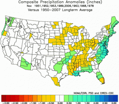
Winter of 1951 - 1952: 23" of snow
Winter of 1952 - 1953: 22" of snow
Winter of 1953 -1954: 9" of snow
Winter of 1963 - 1964: 76" of snow
Winter of 1968 - 1969: 84" of snow
Winter of 1978 - 1979: 51" of snow
Winter of 1989 - 1990: 29" of snow
Winter of 2006 - 2007: 16" of snow
63-64, 68-69, and 78-79 have inflated values due to a slight southerly shifted storm track that gave rise to snow from Gulf Low storms instead of rainfall. Despite these inflated values, I am using these years for temperature/precipitation anomalies, but will omit these years for snow observations.
 |
| Weather Advance predicted storm track, which I am in agreement with (shift the purple line slightly farther inland up to Cape Hatteras). |
So below I have correlation plots of the Multivariate ENSO Index (MEI), Pacific Decadal Oscillation, and Trans-Nino Index compared to precipitation and temperature.
 |
| Correlation of Multivariate ENSO Index with precipitation |
Long story short, but an El Nino makes it wet for the south and dry for the north.
 |
| Correlation of Multivariate ENSO Index with temperature |
Long story short, but an El Nino makes it cool for the south and warm for the north.
 |
| Correlation of Pacific Decadal Oscillation with precipitation |
Long story short, but a negative phase PDO makes it wetter west of the Appalachian Mountains and slightly drier east of the Appalachian Mountains. The correlation is lower early/late season, and the greatest impact is going to be west of the Appalachian Mountains.
 |
| Correlation of Pacific Decadal Oscillation with temperature |
Long story short, but a negative phase PDO makes it warmer across the Southeast. The correlation
is lower early/late season.
 |
| Correlation of Trans-Nino Index with precipitation |
Long story short, but an easterly oriented ENSO slightly wetter across the Southeast but drier across the Deep South. The correlation
is lower for precipitation and really is only pertinent for January and February.
 |
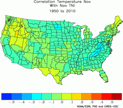
| Correlation of Trans-Nino Index with temperature |
Long story short, but an easterly oriented ENSO slightly warmer
across the South and East coast but cooler for the west coast. The correlation
is lower for temperature and really is only pertinent for January and
February.
 |
| Mean of precipitation anomalies for winters most like our upcoming winter |
And we put it all together for relevant winters, and we get our precipitation anomalies (in inches) per month for what is projected for this upcoming winter. It will be very wet along the Gulf Coast, Deep South, and Mid-Atlantic, but dry across the Ohio River Valley and the Midwest. An active Alberta Clipper track early on saves the interior of the Northeast early this winter.
 |
| Mean of temperature anomalies for winters most like our upcoming winter |
And we put it all together for relevant winters, and we get our temperature anomalies (in fahrenheit) per month for what is projected for
this upcoming winter. It will be a very quick and cool start for our winter, with an abrupt warming trend in January for the eastern portion of the United States. The Southeast has a cool start and escapes the bulk of the warm temperatures in January. They are just slightly above normal for January. Overall the Southeast will have near normal to slightly above average snowfall for this winter and the Mid Atlantic will have above average snowfall. The Northeast will be warmer the second half of this winter but will see near normal snowfall amounts. Lake Effect snow will be plentiful this year with the active Alberta Clipper Track and an anomalously warm Great Lakes. The upper Midwest sees a large decline of snowfall this winter. The central and southern Rockies and Sierra Nevada see higher snowfall.

I do support a near average
to slightly above average snowfall amount for the rest of our state, and
above average snowfall for the majority of the Southeast. The Appalachian Mountains straddle the zone between drier/wetter for the Southeast. Higher snow
density may cut down total accumulations though, especially with a more
active southern storm track. Lake Effect snowfall will be higher
especially with the anomalously warm temperatures the lakes already
have. High pressure anomaly over southeast Canada may be here for the
long haul. My approach got me 33" of
snow using a running mean method and a per month method got me 36" of
snow for the winter. A lot depends on the wild card and that is the
strength of the Polar Vortex